Enregistrez gratuitement cette image
en 800 pixels pour usage maquette
(click droit, Enregistrer l'image sous...)
|
|
Réf : V02071
Thème :
Terre vue de l'espace - Villes (375 images)
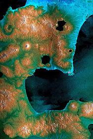
Titre : Radar Image, Hokkaido, Japan
Description : (La description de cette image n'existe qu'en anglais)
The southeast part of the island of Hokkaido, Japan, is an area dominated by volcanoes and volcanic caldera. The active Usu Volcano is at the lower right edge of the circular Lake Toya-Ko and near the center of the image. The prominent cone above and to the left of the lake is Yotei Volcano with its summit crater. The city of Sapporo lies at the base of the mountains at the top of the image and the town of Yoichi -- the hometown of SRTM astronaut Mamoru Mohri -- is at the upper left edge. The bay of Uchiura-Wan takes up the lower center of the image. In this image, color represents elevation, from blue at the lowest elevations to white at the highest. The radar image has been overlaid to provide more details of the terrain.Due to a processing problem, an island in the center of this crater lake is missing and will be properly placed when further SRTM swaths are processed. The horizontal banding in this image is a processing artifact that will be removed when the navigation information collected by SRTM is fully calibrated.This image was acquired by the Shuttle Radar Topography Mission.
|
|

